
Beaver Works Students’ Radar Reflectors Imaged from Space
Each year, MIT’s Beaver Works Summer Institute (BWSI) brings together high school students from around the country to learn about technical topics. This year, staff leading the course on synthetic aperture radar (SAR) collaborated with an outside tech company to give students the opportunity to have their work imaged by a satellite.
BWSI is a collaboration between the Laboratory and MIT’s School of Engineering. Staff members come together to offer courses such as Autonomous Air Vehicle Racing, Remote Sensing for Disaster Response, and E-Textiles and Wearable Technology, all of which are meant to give high school students an introduction to technologies and prepare them for possible future science, technology, engineering, and mathematics (STEM) careers.
The four-week Unmanned Air System–Synthetic Aperture Radar (UAS–SAR) course is designed to provide students with experience building a fully functioning radar imaging system. Before students set foot on campus, they must complete an online course that covers topics such as Python programming fundamentals and radar basics, which exposes them to the background information they need for the course and introduces them to real-world data. On campus, through lectures and hands-on experiments, students learn scientific, engineering, and programming concepts that help them with tasks such as radio frequency (RF) hardware development and data processing. During Week 1, the students build a functioning radar; Week 2 teaches students how to generate radar images; Week 3 challenges the students to integrate the radar system onto small, autonomous air vehicles; and Week 4 concludes the course with an imaging competition.
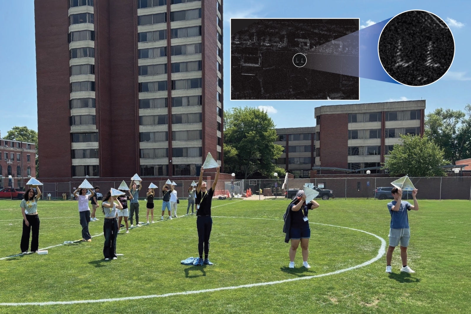
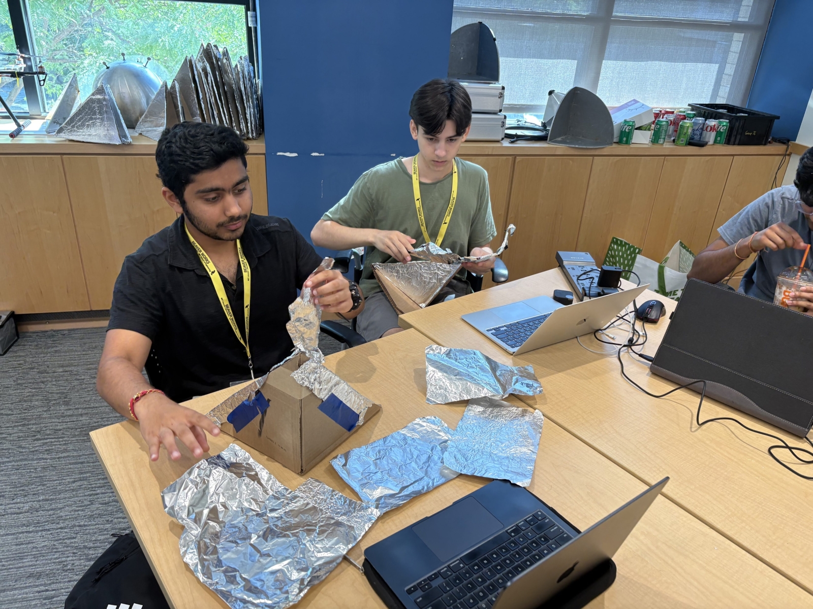
This year, 26 students (mostly rising seniors) participated in the UAS-SAR course. As part of their final project demonstration, course organizers Jess Durkee and Benjamin Marcotte, both of the Airborne Radar Systems & Techniques Group, arranged a partnership with commercial satellite company Umbra, which specializes in high-resolution imagery. The satellite passed over MIT campus and imaged the radar reflectors the students had created out of cardboard and aluminum foil.
“Each year we look for ways to add something new or special to the UAS-SAR course,” said Durkee. “This year we thought the students might be interested to learn more about the modern applications of SAR and, more specifically, spaceborne imaging. Our group does a lot of work with SAR imagery and had worked with Umbra, a commercial satellite company with expertise in SAR, before. As we developed the lecture and began preparations for the course this summer, we realized it would be possible to get an image of our own during the BWSI program from Umbra. We thought having the students involved in the planning, preparing, and processing of a real collection would be engaging, fun, and a good way for them to apply what they were learning to another application of SAR.”
The students were involved in each step of the process, starting with what shape to put their reflectors in and how to organize them, ultimately deciding to write out “LL” for “Lincoln Laboratory.”
“Having the students involved at every step of the collection built up the excitement over the week leading up to it,” said Marcotte. “We were able to get the SAR image from the collection back in just a few hours and actually being able to see themselves in the image was definitely a big boost to the energy in the classroom.”
The satellite passed over MIT campus on 25 July. Course organizers received the images from Umbra and students enjoyed pointing out various Boston landmarks. Some students used what they learned in the course to develop their own algorithms to process the Umbra data and produce their own SAR image, which went above and beyond what was expected in the class.
Overall, the collaboration was a success. The team aims to repeat and improve the process next year, and staff members hope to work with other courses, such as Remote Sensing and Disaster Response, to get student involved in the data collection process. The team is grateful to Beaver Works staff members Lisa Kelley, Beaver Works Operations Manager, Joel Grimm, Beaver Works Manager; Sigrid Flender, Beaver Works Operations Coordinator; Scott Van Broekhoven, Beaver Works Director; and Robert Shin, Beaver Works STEM Director; as well as Airborne Radar Systems & Techniques Group members John Meklenburg and Josh Kantor for making the collaboration possible.
“It was truly a great experience to be a part of, and all of us—staff and students alike—had so much fun out in the field,” said Kelley. “This experience reflects the type of innovative, experiential learning that makes BWSI so impactful and continues to set our program apart.”