
Expanding air traffic controllers' view of offshore weather
Air traffic controllers depend on weather radar for information that enables them to safely reroute aircraft around storms that may cause hail, turbulence, icing, and other hazardous conditions. While land-based radar systems provide reliable weather data covering the continental United States, their effectiveness in capturing data about offshore and over-the-ocean weather systems is limited or nonexistent. Weather radars on board passenger jets can acquire only incomplete views and do not relay information to air traffic control towers. Thus, controllers who manage the large number of aircraft traversing oceanic sectors of the National Airspace System (NAS) are faced with an imperfect weather picture that can threaten the safety of air travel and can lead to inefficient routing of aircraft in the NAS.
Researchers at MIT Lincoln Laboratory, working with the Federal Aviation Administration, have designed the Offshore Precipitation Capability (OPC) to address this lack of airspace situational awareness. The OPC provides radar-like depictions of precipitation intensity and storm height for regions where radar data are inadequate or unavailable.
OPC creates the depictions by fusing together various non-radar data sources—lightning detections, information from geostationary satellites, and outputs from numerical weather prediction models—available within these offshore regions.
"Lightning is a strong indicator of convective weather, that is, weather capable of generating the powerful updrafts which can cause severe turbulence and other safety hazards like damaging hail," explains Mark Veillette, lead of the OPC development team from the Laboratory's Air Traffic Control Systems Group. "In OPC, we use a global lightning dataset that covers areas far offshore and over oceans."
Geostationary satellites positioned around the globe provide visible and infrared imagery of much of the Earth on a fairly regular basis. The Laboratory's researchers used imagery supplied from satellites currently operated by the National Oceanic and Atmospheric Administration (NOAA) to collect data on overland weather to inform the training datasets for OPC.
Numerical weather prediction models simulate many meteorological measurements, including environmental temperature, pressure, and humidity, and other relevant parameters, such as radar reflectivity, rain rate, and convective cloud-top height.
Data from these non-radar sources are combined by using a supervised machine learning framework. The OPC model is "trained" to generate products normally derived from actual weather radar measurements. The fields generated by OPC include a six-level precipitation intensity field and a storm height field, both of which are the standard products used by many air traffic control applications to track storm severity. Results from OPC are blended with outputs from existing radar-based systems to create seamless mosaics of weather systems that extend into offshore and oceanic regions. "OPC fills in gaps in radar coverage on controllers' displays of offshore regions beyond radar range. The output data from OPC are presented in a style and format that match what air traffic controllers are used to seeing on existing weather processing systems," says Veillette.
OPC applies a motion-tracking algorithm to estimate storm motion. This estimated motion is used to spatially shift the features obtained from satellite imagery and numerical models so that OPC can generate up-to-date mosaics in between satellite data updates (which typically occur every 10 to 30 minutes). OPC also incorporates the latest lightning information from global services, such as Earth Networks Total Lightning Network. The capability to produce constantly updated pictures of weather events allows OPC to meet the real-time requirements of the FAA's Next Generation Air Transportation System program, which is upgrading the nation’s air transportation system between 2015 and 2025.
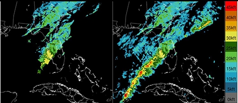
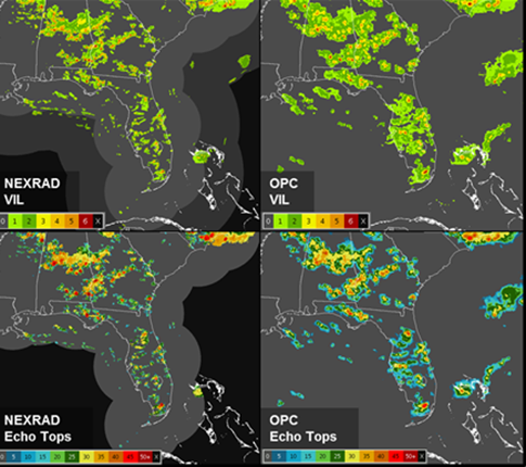
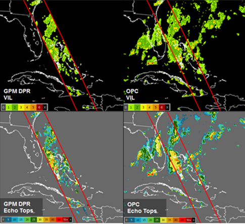
To evaluate the capability's performance, the research team compared OPC-generated displays of weather to over-land radar displays produced by NEXRAD and to offshore and oceanic radar displays produced by the spaceborne radar on board NASA's Global Precipitation Measurement Mission's Core Observatory Satellite. "The comparisons showed that over land OPC can provide a proxy for radar by accurately identifying storm location, intensity, and height and that OPC accurately depicts precipitation intensity and storm height in offshore regions," says Chris Mattioli, technical staff member on the Laboratory's OPC team.
The OPC performance results have been published and presented at multiple national conferences, including the 2016 American Meteorological Society Annual Meeting. Both NOAA and the FAA have begun assessments of the OPC system's accuracy and suitability for deployment to air traffic control centers.
Many other systems designed to provide air traffic controllers with a view of maritime weather conditions are based only on lightning flash densities or solely on infrared satellite imagery. "The key innovation of OPC is its data-driven modeling framework that allows the system to combine multiple heterogeneous meteorological datasets into a single, accurate, and familiar-looking product," says Veillette. "In addition, by including high-resolution inputs, such as visible satellite imagery and lightning density, OPC is able to resolve some finer-resolution storm characteristics that are missed by systems that rely only on infrared satellite or lightning data." The OPC framework provides users with weather analyses that are more accurate than those than those conducted with data from single-source systems.
"[OPC is] useful for anticipating weather deviations and impact in the Gulf of Mexico," commented a Houston-based air traffic controller who participated in an OPC demonstration during summer 2016. Other feedback from FAA air traffic controllers participating in the demo revealed that their confidence in the product, and thus their willingness to base flight plans on it, increased over time.
While OPC was developed primarily for use by U.S. air traffic controllers working in Oceanic Air Route Traffic Control facilities, work is also being done to extend OPC coverage for broader applications such as hurricane tracking, disaster response, and global weather forecasting to monitor all areas lacking radar coverage.