

Space Systems & Technology
In 2025, the first of two SDA payloads, called the QZS6-HP1, launched from Tanegashima, Japan. Sponsored by the U.S. Space Force, we designed, built, and delivered the two payloads as a part of a partnership program between the United States and Japan called the Quasi-Zenith Satellite System Hosted Payload (QZSS-HP). The program formed as a response to the rise in satellite launches across the globe and a shared interest by both nations to fortify SDA in geosynchronous orbit (GEO).
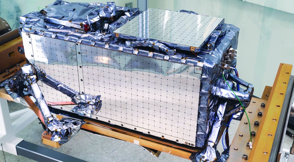
The Laboratory-developed optical sensing system is 45 × 31 × 19 in, with a mass of 136 lbs.
The Space Force engaged Lincoln Laboratory for this program because of our extensive experience in developing SDA sensors, particularly for the ORS-5/SensorSat satellite, which is a small, low-cost alternative to current U.S. capabilities in detecting and tracking objects in GEO. The QZSS payloads leverage SensorSat's compact optical design that allows their sensors to passively survey the sky with high performance. These payloads also accomplish most of their data processing on orbit, causing a 1,000 times reduction in the size of downlinked data, making them an enabling architecture for bandwidth-constrained missions.
The Lincoln Laboratory team is now finalizing on-orbit testing for QZS6-HP1 and preparing for Space Force operations. The second payload has been integrated onto Japan's QZS-7 satellite and is ready for launch.
Air, Missile, & Maritime Defense Technology
Surface-based sonar could map the deep ocean at unprecedented resolution and speed
Precise and rapid seafloor mapping is important for search and recovery, route optimization, hazard avoidance, and critical infrastructure planning. However, traditional mapping methods cannot simultaneously achieve high resolution and speed. Sonars mounted to autonomous underwater vehicles (AUVs) provide detailed images but move slowly with limited endurance, while sonars mounted to ship hulls cover large areas quickly but fail to capture fine detail.
If proven successful, this technology could greatly improve overall effectiveness of ocean exploration and enable the primary goals of the National Strategy for Ocean Mapping, Exploration, and Characterization.
Mashkoor Malik
Chief, Science and Technology Division, NOAA Office of Ocean Exploration and Research
We are teaming up with the MIT Department of Mechanical Engineering Ocean Science and Engineering to develop a surface-based sonar system that could map the seabed up to 50 times faster than AUVs and with 100 times the resolution of conventional surface vessels. The final system will feature a fleet of autonomous surface vessels (ASVs) forming a large sonar array. In progressive tests in the Massachusetts Bay area, our team ran their signal processing software to construct precise seafloor maps based on data collected by a large, towed array of sparsely spaced sonar elements, and separately validated that their ASV positioning sensor suite effectively compensated for wave, current, and wind motion that would otherwise corrupt images. Next, we will integrate these capabilities to demonstrate a scalable seafloor mapping system using the towed array and a single independent sonar element on an ASV.
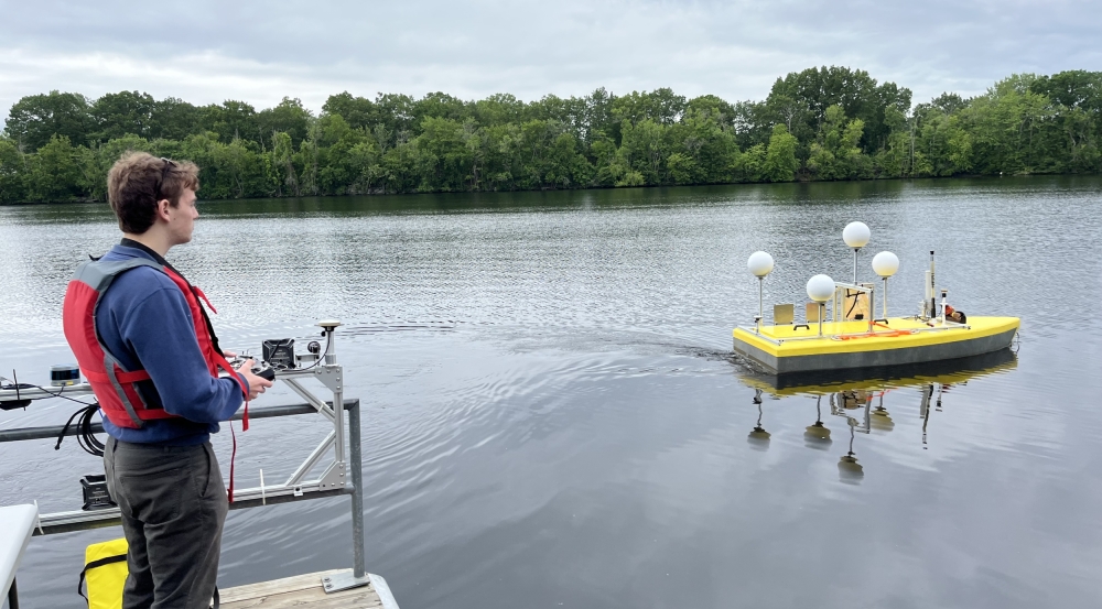
On the Merrimack River, Lincoln Laboratory intern and MIT student Robbie Khazan tests a prototype ASV equipped on the keel with a sonar array for sending and receiving acoustic signals, and above the surface with sensors for relative positioning.
Space Systems & Technology
World-class radars advance U.S. Space Force missions
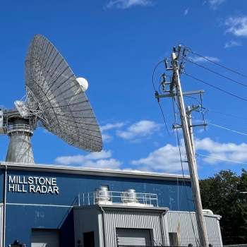
The Millstone Hill Radar, with an 84 ft antenna and 3 MW of peak power, operates at L-band (1.3 GHz) and is capable of tracking satellites in deep space 30,000 miles from the Earth and beyond.
Lincoln Laboratory has built and operates some of the largest and most sensitive radar systems on the planet at the Lincoln Space Surveillance Complex in Westford, Massachusetts. We use these powerful radars to monitor objects in orbit around the Earth, playing a critical role in providing space domain awareness (SDA) for the nation. The radars are equipped with specialized transmit hardware that produces extremely high-power signals, sensitive antennas and electronics that can receive weak signals from great distances, and sophisticated signal-processing software — all pioneered by Lincoln Laboratory. We continually upgrade the systems with state-of-the-art technologies to increase their sensitivity and signal processing capabilities. Through these advancements, the radars remain among the most unique and capable systems available to the nation.
In the past year, a team of 20 operators supported more than 200 launch missions, tracked approximately 30,000 satellites that passed overhead, and produced nearly 10,000 satellite images. Their work involves pre-mission planning, fast-paced operations, and data analysis and interpretation.

The Haystack Ultrawideband Satellite Imaging Radar — featuring a 700,000 lb, 120 ft antenna — operates at both X-band (10 GHz) and W-band (100 GHz). HUSIR can produce 3 cm resolution images of satellites as they pass overhead.
A rise in worldwide launch activity is increasing the volume and complexity of our radar team's work. In response, we are developing new algorithms to simultaneously detect multiple objects in a radar beam, decision support tools to characterize satellites, and novel tactics to address the evolving challenges in SDA today.


