


High-orbit satellites could light the way for travel to the Moon
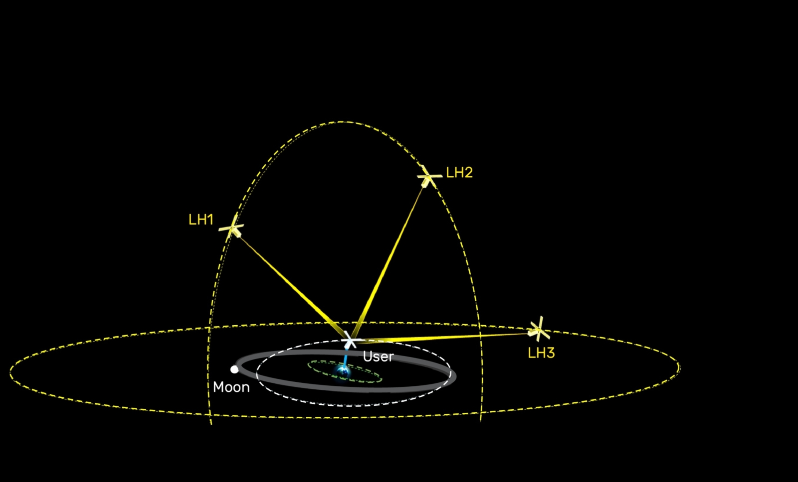
On Earth, the processes behind navigation are made nearly invisible by GPS. In cislunar space — the region between Earth and the Moon — spacecraft do not have that kind of always-available positioning service. Missions beyond geosynchronous Earth orbit still rely heavily on NASA's Deep Space Network (DSN), an accurate but limited Earth-based international array of radio antennas shared across many missions and nations.
Because all DSN sites are located on Earth, their separation is small compared with the scale of cislunar space, which limits the angular baselines available for orbit determination. Therefore, precisely estimating orbits for distant spacecraft can take hours, and DSN supports only a few missions at a time. In addition, DSN requires user spacecraft to actively emit signals for measurement, unlike GPS, which passively sends data for users to receive.
The Laser Communications Group and Advanced Capabilities and Technologies Group at MIT Lincoln Laboratory are developing a concept called the Light High-Orbit Utility Signal Emitter (LightHOUSE) to help overcome these limitations. LightHOUSE would use a small constellation of satellites in high-altitude orbits as cooperative optical beacons. These beacons would exchange timing and communication signals with user spacecraft and use imaging against the stellar background to estimate each spacecraft's three-dimensional position and velocity. By providing timely, independent navigation data across cislunar space, LightHOUSE could reduce the need for corrective maneuvers, preserve spacecraft propellant, lessen the burden on onboard navigation sensors, and ease demand on existing ground-based systems.
"Satellites in cislunar space have limited access to support resources, even though orbits at and beyond the geosynchronous belt are increasingly important for various missions," says Aaron Greenberg, a technical staff member in the Laser Communications Group. "The Moon is reemerging as a strategic priority for national security. Nearly all space missions require some degree of precision navigation and timing, but no global positioning system exists in this domain. Here is where LightHOUSE is intended to step in, expanding critical and reliable communication and navigation services across this vast region."
LightHOUSE would use free-space optical communications — laser links through space — rather than relying solely on radio-frequency systems. The concept builds on Laboratory work demonstrated through NASA-sponsored programs such as TBIRD and O2O, as well as the Optical Time Transfer for Resilient Satellite Communications Networks project led by the Laser Communications Group with funding from the Laboratory's internally administered R&D portfolio in optical systems technology.
"This concept hinges on a cooperative ranging capability enabled by free-space optical communications," says Timothy Yarnall, an associate leader of the Laser Communications Group. "This technology area is one in which the Laboratory is a global leader, as evidenced by the recent O2O success during Artemis II. The Laboratory's experience with radiation hardening of digital focal plane array technology will also enable the sensitive receivers and star cameras – like the camera built by the Advanced Imager Technology Group for NASA's PSYCHE mission — that this concept relies upon."
LightHOUSE beacons would be based in ultrahigh orbits, up to roughly one million miles in altitude. These high orbits replicate the angular diversity of GPS signals for users across cislunar volumes. They would also allow communication with spacecraft on the far side of the Moon as viewed from Earth, preventing blackouts like the 40-minute period when Artemis II passed behind the Moon.
Borrowing from the GPS philosophy, LightHOUSE is designed to place most of the technical burden on the beacon satellites rather than on user spacecraft. The beacons would carry telescopes with tens-of-centimeter diameters and laser transmitters in the tens-of-watts range, while users would need only centimeter-scale apertures and tens-of-milliwatt lasers. The central engineering challenge is making that asymmetry work across cislunar space.
"From a design perspective, a major challenge will be making these services as easily accessible as possible to all potential users. The designed systems would be highly asymmetric, with LightHOUSE beacons taking on most technological and operational demands necessary to close links over the entire cislunar domain," says Seth Trotz, a senior staff member in the Advanced Capabilities and Technologies Group.
Obtaining precise position measurements over such distances — combining optical communications with high-resolution imaging when beacons and user spacecraft are more than half a million miles from Earth — is itself a significant technical hurdle.
The team is now refining the system concept through analysis, simulation, and laboratory experimentation. In the near term, they plan to publish a detailed architecture for providing navigation data to LightHOUSE users. Longer term, the goal is to make navigation beyond geosynchronous altitudes routine, reliable, and accessible for a broad range of users, supporting Artemis and the growing wave of missions to follow in cislunar space.
This work is sponsored by the Under Secretary of War for Research and Engineering through the Laboratory's internally administered R&D portfolio in sensing and communications. A full-scale system would require substantial investment, potentially on the order of hundreds of millions of dollars; for comparison, the operating budget of GPS is $1.8B per year, and a single DSN dish costs roughly $85M to $100M.
Inquiries: contact Ariana Gaines.
Related Links
- Artemis II live-streams hi-def videos and images from the Moon to Earth
- Lincoln Laboratory laser communications terminal launches on historic Artemis II Moon mission
- ILLUMA-T launches to the International Space Station
- NASA's record-breaking laser demo completes mission
- Communications system achieves fastest laser link from space yet