Advanced Sensing for Hydrological Metrology
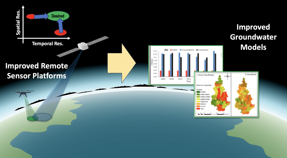
Climate change and changes in human resource utilization will lead to significant changes in groundwater resources, thus motivating accurate hydrologic measurements and models. Lincoln Laboratory is collaborating with Alabama A&M University to identify existing gaps in hydrological measurements and models and potential technological solutions, leveraging the Laboratory's expertise in remote sensing and data analysis.
Today’s models are insufficient for informing critical decisions in a wide array of areas, including agriculture and land use, response to contamination incidents, facility siting, international agreements, and military planning. Data sources feeding these models need to be better grounded in, calibrated against, and updated with truth data, which currently suffers from inadequate spatial and temporal resolution, coverage, and persistence.
This study is seeking out new opportunities to apply emerging technologies to improving these data sources. For example, new sensor modalities may provide phenomenological data that are not being used in current models. Developments in low–size, weight, and power sensor platforms and adaptive and agile sensors may offer new ways to push the limits imposed by today’s trade space between resolution, coverage, persistence, and cost. Advances in autonomy may allow for event-driven tasking of sensors to provide additional data for times and locations of high sensitivity. The ultimate goal of the effort will be to propose a new mission concept that builds on these technological advances to maximize the value of data for critical hydrologic modeling needs.
Related
News

Ultra-efficient AI won’t solve data centers’ climate problem. This might.

Q&A with Vijay Gadepally on the climate impact of generative AI

44 years ago, this Utah national monument made history
An AI dataset carves new paths to tornado detection
Publications
Near-term regional climate change over Bangladesh
Staff