
Air Traffic Control and Weather Systems
The Air Traffic Control and Weather Systems Group’s mission is to develop and deploy advanced weather sensing, forecasting, and decision support technologies with a focus on enabling safe, efficient, and cyber-secure air transportation. These technologies are designed to address the needs of a range of key users, including air traffic controllers, pilots, airlines, regulators, and other decision makers. To ensure user acceptance and maximize the operational impact of our technologies, we rely on extensive analysis and field evaluations, drawing upon diverse areas of expertise within the group, including aviation operations, meteorology, cybersecurity, multimodal sensing, software engineering, artificial intelligence/machine learning, and human factors. The technologies we have developed are currently operating across North America to minimize weather-related delays to the flying public. We are also actively working in emerging aviation and weather decision support need areas, such as enabling globally harmonized air traffic control systems, assessing cyber vulnerabilities of aircraft and ground-based systems, and developing technologies to enable the safe integration of advanced air mobility and commercial space operations into the air transportation system.
Featured Projects
aviation weather
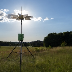
Portable Aircraft-Derived Weather Observation System
A low-cost technology can increase the number and quality of wind and temperature atmospheric observations made by aircraft to improve forecasts.
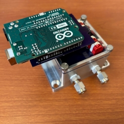
Low-Cost Methane Sensor Network
Deploying large networks of ground-based methane detectors could help detect pipeline leaks, improve climate models, and regulate emission sources.
air traffic control
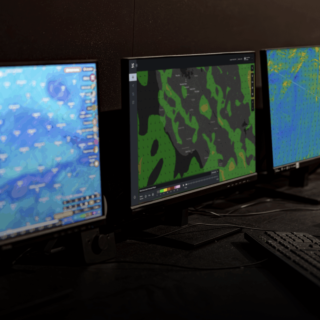
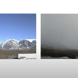
Visibility Estimation through Image Analytics
An algorithm uses camera imagery to estimate visibility for pilots flying in remote areas that lack weather sensors.
aviation weather
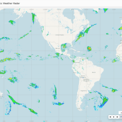
Global Synthetic Weather Radar
By compiling lightning data, satellite imagery, and numerical weather models, the GSWR provides radar-like analyses and forecasts over regions not observed by actual weather radars.
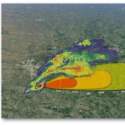
Intelligent Tornado Prediction Engine
We compiled a massive open-source dataset to develop deep learning models capable of detecting and predicting tornadoes.
Latest News
In the Media
Oct 28
SkyGrid

Laboratory Stories
I'm transitioning research tasks into operational algorithms that help the Federal Aviation Administration improve safety and efficiency.
James Kurdzo
Radar Meteorologist
Air Traffic Control
Air Traffic Control and Weather Systems

Advancing Our Research
Featured Publications
ECP 0857P final report for the NEXRAD ROC: Modified VCP 35
Sep 18
MIT Lincoln Laboratory Report ATC-456
WSR-88D microburst detection performance evaluation
Nov 28
MIT Lincoln Laboratory Report ATC-455
Radio frequency interference censoring scheme for Canadian Weather Radar
Jul 12
MIT Lincoln Laboratory Report ATC-454