
Projects
Tagged As
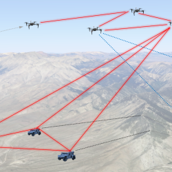
Precision Clock Synchronization for Advanced Sensing
Combined quantum networking and lasercom optical signaling techniques could impact advanced sensing applications such as geolocation with distributed systems.
Tags
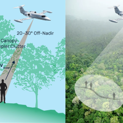
Finding People Under the Rainforest Roof with Lidar
Lincoln Laboratory is exploring the feasibility of building an airborne sensing system to detect the presence of humans under dense tree canopy.
Tags
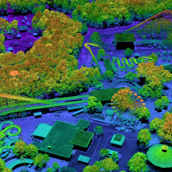
PHOENIX High CASTLE
We developed a ladar that samples at the diffraction limit to collect high-resolution imagery for geospatial mapping missions.
Tags

Air Vehicle Survivability Evaluation
For more than 40 years, Lincoln Laboratory has provided the Air Force with assessments on potential technologies for assuring the survivability of Air Force aircraft.
Tags