
Projects
Tagged As

Testing Infrastructure for Evolved Strategic SATCOM System
The satellites will provide global coverage to warfighters for the nation's nuclear command, control, and communications mission.
Tags
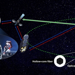
Guiding Light in Air-Filled Fibers for Long-Distance Lasercom
A new type of fiber could transmit the high-power light needed for future deep-space science and exploration missions.
Tags

High-Assurance Cryptography
Lincoln Laboratory is developing technologies to meet the highest standards for information security at the tactical edge.
Tags
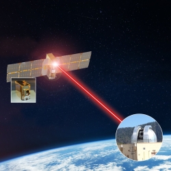
TeraByte InfraRed Delivery (TBIRD)
The laser communications payload has delivered terabytes of data from a satellite to Earth at record-breaking rates that will transform future science missions.
Tags
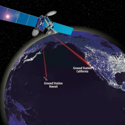
Laser Communications Relay Demonstration
Optical communications technologies decades in the making at Lincoln Laboratory were transferred to NASA for its first two-way laser relay communications system.
Tags
Space Systems Cyber-Resiliency
We are researching and prototyping cyber-resilient space systems software that will enable critical national security space assets to withstand, operate through, and recover from cyberattack.
Tags

Geostationary Operational Environmental Satellite Series
The Laboratory's long-term collaboration with NOAA and NASA on environmental monitoring satellites has led to revolutionized weather imagery and products and improved detection for space and solar phenomena.
Tags
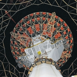
Haystack Ultrawideband Satellite Imaging Radar
Lincoln Laboratory created the world's highest-resolution radar for imaging of space objects in support of space situational awareness.
Tags
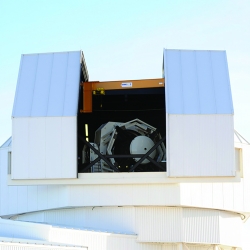
Space Surveillance Telescope
A unique curved focal surface enables a highly sensitive telescope capable of surveying broad swaths of deep space to detect the faintest objects in the night sky.
Tags

Transiting Exoplanet Survey Satellite
A new planet hunter will spend the next two years searching for exoplanets, including those that could support life.
Tags