Measuring Subsurface Ocean Properties from the Air
Accurate knowledge of ocean temperatures, salinity, and currents — particularly in the upper layers of the ocean — is critical to many U.S. Department of War missions: naval operations, undersea warfare, amphibious landings, and autonomous system deployment. Varying ocean conditions can impact the detection range and accuracy of sonar, reliability of communication systems, and maneuverability of submarines and other vessels. In addition, real-time, high-resolution measurements of the ocean's state enhance mission planning and effectiveness across global areas of operation.
However, the ocean's size, unpredictable behavior, and unique physical properties present challenges for data collection. The ocean is sensitive to small-scale changes, which can trigger cascading effects that are hard to forecast. Because seawater is nearly opaque to much of the electromagnetic spectrum, subsurface sensing, communication, and localization capabilities are limited. Currently, subsurface observations largely rely on slow-moving ocean-deployed platforms like buoys, resulting in sparse data insufficient for generating highly accurate operational global ocean models and forecasts.
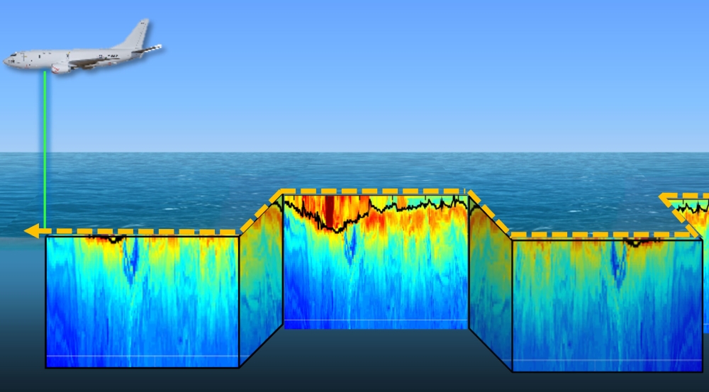
To fill this gap, the Laboratory is developing an airborne sensor that uses laser light to remotely measure subsurface ocean sound speed, temperature, and salinity (which are indirectly related to currents). The sensor exploits the phenomenon of Brillouin scattering, in which light scatters and slightly shifts in wavelength after interacting with sound waves within a medium. The sensor features two components: a lidar that sends pulses of laser light into the ocean and measures depth by timing the return of the scattered light, and a spectrometer that analyzes the spectral characteristics of the scattered light to deduce subsurface physical properties.
Lidar spectrometers developed to date have been unable outside laboratory environments to maintain the precision needed for measuring subsurface ocean properties via tiny Brillouin wavelength shifts. Field-deployable systems on airborne platforms like airplanes or helicopters must be robust to motion and vibration, which can distort measurements. In addition, the ocean strongly absorbs laser light, necessitating a way to capture as much of the weak, scattered signal as possible. The team's design overcomes these limitations by utilizing specialized optics to obtain a wide field of view and an atomic dispersive interferometer (a type of spectrometer that is highly sensitive to the wavelength response of atoms in a vapor) to precisely measure tiny Brillouin wavelength shifts while minimizing measurement errors stemming from background noise and platform vibration.
The team is now building the hardware for an initial laboratory demonstration, followed by at-sea testing. Combining strengths of two established technologies — namely, the high area-coverage rates of remote-sensing platforms and the depth-profiling capability of ocean-deployed platforms — this lidar spectrometer would be the first of its kind, opening entirely new avenues for ocean sensing and forecasting.
Related
News