TROPICS

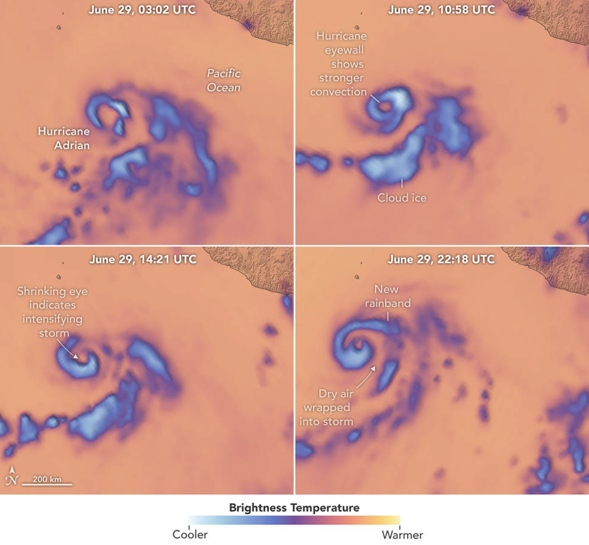
A team of storm-observing satellites is offering scientists a new tool for understanding the inner workings of extreme storms over shorter time spans. The TROPICS mission (short for Time-Resolved Observations of Precipitation structure and storm Intensity with a Constellation of Smallsats) consists of four small satellites in low Earth orbit that are providing near-hourly measurements of temperature, water vapor, precipitation, and cloud ice over the Earth’s tropical belt, where hurricanes, cyclones, and tropical storms form. The data will provide more insight into how atmospheric conditions impact tropical storm intensification.
The satellites collect these data by using a microwave radiometer, a sensor that detects the thermal radiation emitted by oxygen and water vapor in the air. The TROPICS instrument measures these emissions at different heights throughout the atmosphere, corresponding to 12 RF channels between 90 gigahertz and 205 gigahertz. The 205-gigahertz channel is the highest frequency ever used on a space-borne microwave cross-track-scanning radiometer. This channel can enable scientists to learn more about mechanisms in the cloud formation process. For example, they can more closely observe the transition of liquid cloud droplets to ice cloud crystals, which are an important component in cloud formation processes and are not observed with sufficient fidelity by current microwave, infrared, or visible systems.
On traditional weather satellites, microwave radiometers are the size of a washing machine. On TROPICS, the sensor is the size of a coffee cup. Over the last decade, Lincoln Laboratory has worked to achieve this miniaturization with little compromise in performance, with the goal of outfitting small, inexpensive satellites for targeted weather observations.
The TROPICS satellites’ near-hourly revisit time is not currently possible with other satellites that fly microwave radiometers. Since tropical cyclones and hurricanes can change rapidly as they travel across the ocean, the increased observations from the TROPICS satellites will not only advance the science of understanding storm intensity but also may improve intensity forecasts.
Related
News
Lincoln Laboratory honored for technology transfer of hurricane-tracking satellites

Small, nimble weather satellites could track the atmosphere moment by moment, boosting forecasts
Publications
ECP 0857P final report for the NEXRAD ROC: Modified VCP 35
Impacts of WSR-88D SAILS and MRLE VCP options on severe weather warning performance
WSR-88D microburst detection performance evaluation
Visibility estimation through image analytics
Staff

William J. Blackwell